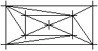
Meshing a grid
 Tools: Mesh, Optimize Grid
To create a new digital terrain model
- Click
 Mesh, Optimize Grid (How).
 - Click New in the input options.
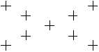
- Open a selection rectangle around the points to be meshed. Profile points and elevation points will be ignored.
Alternatively, right-click in the workspace twice to address all valid points.
Notes:
- A DTM must contain at least three points.
- In the case of two or more congruent points, only one will be meshed.
- When you work with drawing files, all the points must lie in the same drawing file. This is not necessary if they are "linked" to elements that are then generally duplicated.
- You can use
 Mesh Element with DTM to mesh profile points and elevation points with the model.
 - A DTM can have up to 300,000 points. If the number of points exceeds this value, use a number of smaller submodels. Consequently, calculations are faster and results are more accurate.
We recommend that you use a document size of at least 1024 MB (the default is 512 MB) when you work with digital terrain models. Sometimes a smaller value can be sufficient. However, when you work with more than 10,000 points, always increase the document size to the value recommended for your hardware. To do this, use the docsize hotline tool in the Services application. When you work with the maximum document size, make sure the current document never exceeds the limit specified. - If you cannot see all the elements after creating the DTM, check the settings in
 Representation.