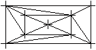
Mesh grid
 Module(s): Digital Terrain Model
To create a new digital terrain model
- Click
 Mesh, Optimize Grid (How).
 - Click New in the Input options.
- Press and hold down the left mouse button and define a selection rectangle around the points to be meshed. Profile points and elevation points are ignored.
Alternatively, double click in the workspace with the right mouse button to address all valid points.
Notes:
- A DTM must comprise at least three points.
- In the case of two or more congruent points, only one will be meshed.
- When you work with drawing files, all the points must lie in the same drawing file. This is not necessary if they are "linked" to elements that are then generally duplicated.
- Profile points and elevation points can be meshed with the model using Mesh Element with DTM.
- A DTM may have up to 300,000 points. If the number of points exceeds this value, we recommend using a number of smaller 'sub-models.' This is also advisable to accelerate the calculation and ensure that it is more accurate.
We recommend that you set the document size to 256 MB (the default is 64 MB) when you work with digital terrain models. Sometimes a smaller value may be enough. However, when working with more than 10,000 points, you should always increase the document size to the value recommended for your hardware. To do this, use the docsize hotline tool in the Services application. When you set the document size to optimum, pay attention to the active document. It must never exceed 128 MB. - If only specific elements are visible in the workspace after creating a DTM, check the settings in Representation.