![]() Importing files with large coordinates
Importing files with large coordinates
First, analyze the file in order to determine the current offset values. As this does not involve importing the file, just cancel the dialog boxes.
If possible, the values required are automatically taken from the file to be imported.
To determine the offset values required
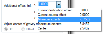
You can analyze the additional offset in the Coordinates and length parameters area of the General Settings tab. Click the x, y and z list boxes to determine the maximum and minimum coordinates of the file.
Site plans usually contain positive values. To get suitable offset values, all you need to do is leave the constant digits of the maximum and minimum coordinates as they are and replace the digits that vary with zeros:
Note: You can use a simplified solution for Gauss-Krüger and UTM coordinates (i.e. site plans). As these coordinates are based on geographic meridians, there are only a few suitable offsets you can use. These offsets, which do not change, are well-known so that you do not need to determine them. Please make sure that you do not mistake the axes.
Depending on the file and origin, the following offsets are useful in Germany (without guarantee):
As you can see, only the first two digits of an offset are considered to be constant so that the other coordinate values saved are the same throughout Germany.
| (C) Allplan GmbH | Privacy policy |

