![]()
![]()
|
|
|
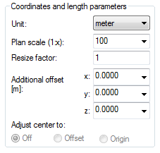
Coordinates and length parameters
Unit
This is where you set the unit of the source file (during import) or the unit of the target file (during export). You should discuss this with your data exchange partner.
MicroStation V8 [ ODA v4.01 ] fileset (*.dgn) V8.0:
Allplan automatically imports the data using the source file's unit of length.
Allplan automatically exports the data using the unit of length you defined (![]() Options - Desktop environment or status bar).
Options - Desktop environment or status bar).
Note: When you set the file type to MicroStation V8, you can only change the unit using the ![]() Options - Desktop environment or the status bar.
Options - Desktop environment or the status bar.
Note: In some systems, the unit in which lengths and coordinates are saved is predefined and must therefore not be altered here. If you want to adjust coordinates and lengths, use the Resizing factor option.
Layout scale
For the scale, set the desired destination scale to be used when editing the drawing. This setting controls the extents of points, text, symbols, line types and patterns.
Note: This parameter can only be set manually with certain source and destination systems.
Resizing factor
You can use this to enlarge (>1) or reduce (<1) coordinates and length values in the data being converted. Unlike the Unit parameter, this parameter can always be selected.
Additional offset
You can move the data by a value you specify. This changes the coordinates themselves. Use this option only if you require the data only for internal use and you do not need to export the data again (coordinates in site plans are legally binding).
Allplan automatically uses the unit of length you defined using the ![]() Options - Desktop environment or the status bar.
Options - Desktop environment or the status bar.
Note: Using the Consider project offset option, you can configure Allplan to consider the offset defined in the Project Settings when exporting data.
Adjust center of gravity to (for import only)
Off: the file is not changed.
Offset: automatically sets an offset in the project properties. Consequently, the origin of the file (= center of the min-max-box) is set to the origin of the coordinate system. This option is not available when you have already specified an offset.
Origin: moves the center of the file to the origin of the coordinate system. As opposed to the previous option, the coordinates themselves are changed. Use this option only when you do not have to export the data again.
|
(C) ALLPLAN GmbH |
Privacy policy |
