![]() Polygonize entire element
Polygonize entire element
This uses the entire element that you clicked. The starting point defines the direction of polygonization. If the last point in the polyline coincides with the start or end point of the element, the direction does not need to be specified.
Use this option when the outline consists of entire elements.
![]() Define area of element to polygonize
Define area of element to polygonize
With this option, the program prompts you for the area with every element you click (from point, to point).
Use this option when the outline consists of segments.
![]() Enter reference point
Enter reference point
With this option, the program prompts you for the reference point with every element you click. This option uses a point on the element you clicked with a defined offset to the reference point. Click to define a new reference point and then enter the offset to the reference point.
Use this option when you want to specify the outline based on existing elements (when you enter a dormer, for example).
![]() Area detection using additional point
Area detection using additional point
This combines areas bounded by lines and polylines to form a polygon. The inner or outer boundaries are used depending on whether the temporary point is inside or outside the outline.
By selecting ![]() Element filter, you can configure the program to ignore architectural lines when detecting areas.
Element filter, you can configure the program to ignore architectural lines when detecting areas.
![]() Rise
Rise
The polygonization value is interpreted as the rise. The value you enter for ![]() Rise defines the maximum rise of the secant relative to the arc (in mm). As a result, the curve is polygonized so that the maximum offset of the polyline's segment to the curve is less than or equal to the value your specified. This setting produces more accurate results than the number of segments.
Rise defines the maximum rise of the secant relative to the arc (in mm). As a result, the curve is polygonized so that the maximum offset of the polyline's segment to the curve is less than or equal to the value your specified. This setting produces more accurate results than the number of segments.
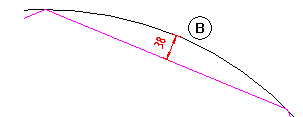
(B) Rise (38mm or less)
| (C) Allplan GmbH | Privacy policy |