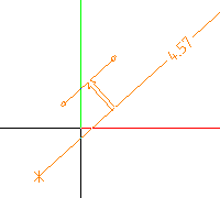
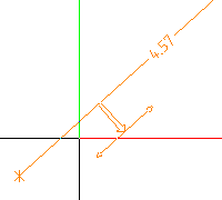
Elevation point
 Module(s): Dimension Lines
You can use the  Elevation Point tool to create elevation dimensioning.
To create elevation dimensioning
- Click Elevation Point (How).
- If you want, you can now modify the dimension line's parameters.
are provided on the context toolbar for this. - Select the type:
 Vertically upwards
 Vertically downwards
 Horizontally to the right
 Horizontally to the left
 Any direction
- In addition, you can select the and options.
- Define the .
If you have selected Any direction, the system will now prompt you to specify the direction:
- The following options are presented on the context toolbar:
- You can change the Base value for the reference point if you have not yet placed a reference point. Click
 to copy the Base value for the reference point from a dimension line that already exists.
 - You can change the global parameters of the dimension line at any time. are provided on the context toolbar for this.
- You can select a different Arrowhead for the next point to be dimensioned.
- Click
 Undo last entry to undo the last point you clicked.
- Click the reference point.
- Click the first point to be dimensioned.
- Click more points to be dimensioned.