![]()
![]()
|
|
|
Using the Save Contents of Viewport as a Bitmap tool on the File menu, you can now create GeoTIFF files. When you save the data in TIFF Format, the coordinates required for georeferencing are automatically taken from Allplan and saved as metadata.
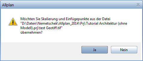
When you import GeoTIFF and GeoJPEG files using ![]() Bitmap Area, the geographic information is detected and analyzed as always, regardless of whether this information is embedded in the file itself or available as text files with the extension TFW or JGW. The resizing factor and drop-in point can be taken from the file; in this case, you are not prompted to specify the drop-in point.
Bitmap Area, the geographic information is detected and analyzed as always, regardless of whether this information is embedded in the file itself or available as text files with the extension TFW or JGW. The resizing factor and drop-in point can be taken from the file; in this case, you are not prompted to specify the drop-in point.
| (C) Allplan GmbH | Privacy policy |